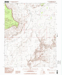
1996 Map of Red House Spring
USGS Topo · Published 2002About this map
Red House Spring and the surrounding desert corridor of San Juan County are documented here as they appeared in the late 20th century. This arid landscape is defined by its dramatic verticality, where the massive Red House Cliffs and Clay Hills drop into a complex network of erosional drainages. The map reveals the intricate path of Grand Gulch, including a distinctively tight passage known as The Narrows, which serves as a primary drainage route toward the south.
Find a feature on this map
11 named features on this map. Tap any name to fly to it.
Don’t see what you’re looking for? This feature index may not catch every label — zoom into the map to look around manually.
Map Details
Editions of this 1996 Red House Spring Map
2 editions found
Other maps of this area

1886 · Henry Mountains
USGS Topo · 1:250,000

1892 · Henry Mountains
USGS Topo · 1:250,000

1952 · Mancos Mesa
USGS Topo · 1:62,500

1952 · Natural Bridges
USGS Topo · 1:62,500

1954 · White Canyon 3 SE
USGS Topo · 1:24,000

1954 · White Canyon 4 SE
USGS Topo · 1:24,000

1954 · White Canyon 4 SW
USGS Topo · 1:24,000

1954 · Clay Hills 2 NE
USGS Topo · 1:24,000

1954 · Clay Hills 2 SE
USGS Topo · 1:24,000

1954 · Clay Hills 1 NW
USGS Topo · 1:24,000