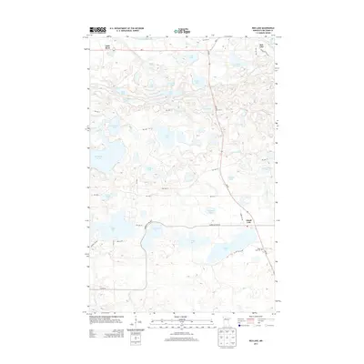
2013 Map of Red Lake
USGS Topo · Published 2013About this map
Lower Red Lake dominates the northern horizon of this landscape in Beltrami County, where a dense network of glacial basins and drainage channels defines the terrain. The settlement of Little Rock sits near the shore, connected by MN-1 to the surrounding wilderness of the Red Lake Reservation. This area is characterized by an incredible concentration of named water bodies, including the large Kesagiagan Lake and Thunder Lake, which likely served as significant landmarks for local navigation and subsistence long before modern surveying. Moving south along MN-89, the land transitions toward the community of Island Lake, where the Island Lake Cem provides a point of genealogical interest for those tracing family roots in northern Minnesota. Numerous reservation highways and local routes like Lumberjack Rd NW and Res Hwy 39 cut through the wetlands, linking smaller lakes such as Balm Lake and Mina Lake to the primary settlements.
Find a feature on this map
49 named features on this map. Tap any name to fly to it.
Don’t see what you’re looking for? This feature index may not catch every label — zoom into the map to look around manually.
Map Details
Editions of this 2013 Red Lake Map
This is the sole edition of this map. No revisions or reprints were ever made.
Other maps of this area

1919 · Solway
USGS Topo · 1:62,500

1920 · Buena Vista
USGS Topo · 1:62,500

1943 · Solway
USGS Topo · 1:62,500

1954 · Bemidji
USGS Topo · 1:250,000

1957 · Bemidji
USGS Topo · 1:250,000

1958 · Bemidji
USGS Topo · 1:250,000

1972 · Bagley Lake
USGS Topo · 1:24,000

1972 · Redby
USGS Topo · 1:24,000
1972 · Debs
USGS Topo · 1:24,000
1972 · Red Lake
USGS Topo · 1:24,000