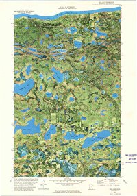
1972 Map of Red Lake
USGS Topo · Published 1974About this map
The Red Lake Indian Reservation shoreline along Lower Red Lake anchors this early 1970s orthophotomap, revealing a landscape defined by an intricate network of glacial lakes and wetlands. The settlement of Red Lake serves as the primary hub, situated near the northern edge where Point Creek enters the lake. This hybrid topographic-aerial view provides unique insight into the traditional and modern use of the land, showing the placement of the Sewage Disposal Pond and a Gravel Pit alongside significant local landmarks. Moving south toward the elevation of Maple Ridge, the terrain becomes densely packed with water bodies such as Kesagiagan Lake, Balm Lake, and Mina Lake. Genealogy and local history details are preserved through the location of the Dell Chapel and burial sites like the Red Lake Cem and Island Lake Cem.
Find a feature on this map
40 named features on this map. Tap any name to fly to it.
Don’t see what you’re looking for? This feature index may not catch every label — zoom into the map to look around manually.
Map Details
Editions of this 1972 Red Lake Map
This is the sole edition of this map. No revisions or reprints were ever made.
Other maps of this area
1919 · Solway
USGS Topo · 1:62,500

1920 · Buena Vista
USGS Topo · 1:62,500
1943 · Solway
USGS Topo · 1:62,500

1954 · Bemidji
USGS Topo · 1:250,000

1957 · Bemidji
USGS Topo · 1:250,000

1958 · Bemidji
USGS Topo · 1:250,000

1972 · Bagley Lake
USGS Topo · 1:24,000
1972 · Redby
USGS Topo · 1:24,000

1972 · Debs
USGS Topo · 1:24,000

1972 · Aure
USGS Topo · 1:24,000