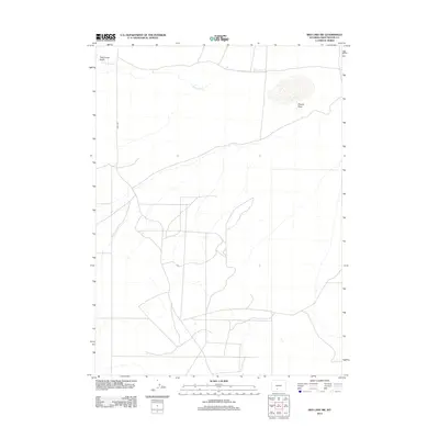
2012 Map of Red Lake SW
USGS Topo · Published 2012About this map
Black Rock Cr meanders across the northern reaches of this Sweetwater County landscape, highlighting a region defined by its arid drainage patterns and remote road networks. The terrain is marked by significant natural depressions and watercourses such as Twelvemile Gulch in the northwest and the expansive Dugout Draw to the east. A complex system of unpaved tracks and local routes, including the prominent Bar X Rd, crisscrosses the southern half of the map. These pathways suggest a history of land management and access for ranching or resource extraction in the high desert of southwest Wyoming. The 2012 survey provides a clear view of the topography before further modern development, preserving the alignment of these secondary roads and the seasonal flow of the creeks.
Find a feature on this map
4 named features on this map. Tap any name to fly to it.
Don’t see what you’re looking for? This feature index may not catch every label — zoom into the map to look around manually.
Map Details
Editions of this 2012 Red Lake SW Map
This is the sole edition of this map. No revisions or reprints were ever made.
Other maps of this area

1954 · Rock Springs
USGS Topo · 1:250,000

1958 · Rock Springs
USGS Topo · 1:250,000

1958 · Twelvemile Well
USGS Topo · 1:62,500

1960 · Red Lake
USGS Topo · 1:62,500

1962 · Rock Springs
USGS Topo · 1:250,000

1968 · Bitter Creek NE
USGS Topo · 1:24,000

1970 · Tipton
USGS Topo · 1:24,000
1970 · Desert Springs
USGS Topo · 1:24,000
1980 · Red Desert Basin
USGS Topo · 1:100,000
1986 · Black Rock Flat East
USGS Topo · 1:24,000