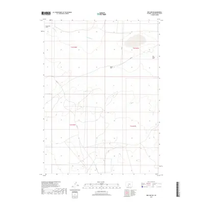
2017 Map of Red Lake SW
USGS Topo · Published 2017About this map
Red Desert Basin dominates this landscape in Sweetwater County, where the high desert floor is carved by ephemeral drainage systems. The northern portion of the sheet is defined by the winding course of Black Rock Cr, which is fed by rugged terrain features like Twelvemile Gulch. While the area remains largely uninhabited, a network of utility and local access routes, including Co Rd 21 and Co Rd 20, navigate the depressions and draws. The presence of Dugout Draw suggests the historical reliance on seasonal water runoff and natural catchment in this arid environment. This 2017 survey reflects the enduring, open character of Wyoming's interior basins, providing a detailed look at the township and range boundaries that still define land management in the region today.
Find a feature on this map
11 named features on this map. Tap any name to fly to it.
Don’t see what you’re looking for? This feature index may not catch every label — zoom into the map to look around manually.
Map Details
Editions of this 2017 Red Lake SW Map
This is the sole edition of this map. No revisions or reprints were ever made.
Other maps of this area

1954 · Rock Springs
USGS Topo · 1:250,000

1958 · Rock Springs
USGS Topo · 1:250,000

1958 · Twelvemile Well
USGS Topo · 1:62,500

1960 · Red Lake
USGS Topo · 1:62,500

1962 · Rock Springs
USGS Topo · 1:250,000

1968 · Bitter Creek NE
USGS Topo · 1:24,000

1970 · Tipton
USGS Topo · 1:24,000
1970 · Desert Springs
USGS Topo · 1:24,000
1980 · Red Desert Basin
USGS Topo · 1:100,000
1986 · Black Rock Flat East
USGS Topo · 1:24,000