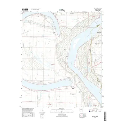
2017 Map of Red Leaf
USGS Topo · Published 2017About this map
The Mississippi River carves a massive, winding path through this Delta landscape, defining the state boundary between Arkansas and Mississippi. Along its western banks in Arkansas, the oxbow of Lake Chicot and the remnants of Whiskey Chute illustrate the river's historical shifts and the resulting complex drainage patterns of Ditch Bayou and Weaver Bayou. Small settlements and landings like Red Leaf, Sunnyside, and Vaucluse are positioned near the massive Levee Rd, reflecting a landscape deeply shaped by flood control and agricultural utility.
Find a feature on this map
65 named features on this map. Tap any name to fly to it.
Don’t see what you’re looking for? This feature index may not catch every label — zoom into the map to look around manually.
Map Details
Editions of this 2017 Red Leaf Map
This is the sole edition of this map. No revisions or reprints were ever made.
Other maps of this area

1936 · Eudora
USGS Topo · 1:62,500

1936 · Lake Village
USGS Topo · 1:62,500

1939 · Readland
USGS Topo · 1:62,500

1939 · Refuge
USGS Topo · 1:62,500

1953 · Greenwood
USGS Topo · 1:250,000

1955 · Lake Village
USGS Topo · 1:62,500

1956 · Greenwood
USGS Topo · 1:250,000

1957 · Eudora
USGS Topo · 1:62,500
1970 · Luna
USGS Topo · 1:24,000
1970 · Greenville
USGS Topo · 1:24,000