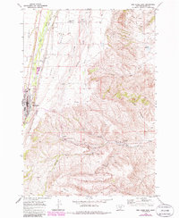
1969 Map of Red Lodge East
USGS Topo · Published 1986About this map
Industrial activity and ranching terrain converge east of Red Lodge, where the landscape transitions from the riparian corridor of Rock Creek to the high plateaus of West Bench and East Bench. This 1969 survey, revised with early 1980s data, documents a region defined by extensive coal mining and resource extraction. The area around Bearcreek and Washoe is heavily marked by several operations, including the Brophy Mine, Smith Mine, Burns Mine, and a Strip Mine, alongside numerous mine dumps and a Water Tank.
Find a feature on this map
42 named features on this map. Tap any name to fly to it.
Don’t see what you’re looking for? This feature index may not catch every label — zoom into the map to look around manually.
Map Details
Editions of this 1969 Red Lodge East Map
3 editions found
Other maps of this area

1932 · Red Lodge No 2
USGS Topo · 1:48,000

1932 · Red Lodge No 1
USGS Topo · 1:48,000

1944 · Red Lodge
USGS Topo · 1:62,500

1954 · Billings
USGS Topo · 1:250,000

1956 · Roberts
USGS Topo · 1:24,000

1956 · Mount Maurice
USGS Topo · 1:62,500

1956 · Castagne
USGS Topo · 1:24,000

1956 · The Big Slide
USGS Topo · 1:24,000

1957 · Billings
USGS Topo · 1:250,000

1958 · Billings
USGS Topo · 1:250,000