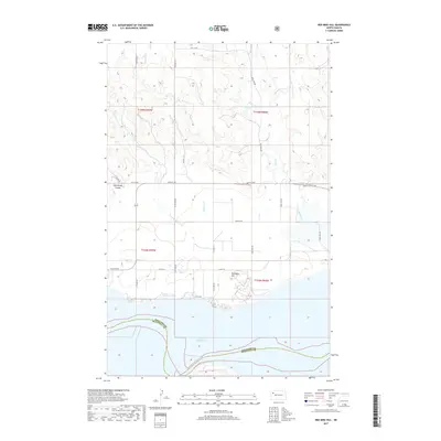
2017 Map of Red Mike Hill
USGS Topo · Published 2017About this map
Lake Sakakawea dominates the southern landscape of this Williams County quadrangle, marking the shoreline where the Missouri River was transformed by mid-century engineering. The terrain rises north from the water toward the prominent Red Mike Hill, an area defined by the deeply incised drainage of Beaver Cr and Thorsen Cr. This 2017 survey reflects a sparsely populated rural landscape where section-line roads like 57th Ln NW and 54th St NW create a rigid grid over the undulating coulees. The proximity of the Williams Co McKenzie Co boundary within the reservoir highlights the topographical changes that redefined local geography after the reservoir's creation. Smaller landforms like Half Breed Coulee and Nelson Cr provide specific points of reference for researchers tracing the historical drainage patterns and land use in this part of North Dakota.
Find a feature on this map
24 named features on this map. Tap any name to fly to it.
Don’t see what you’re looking for? This feature index may not catch every label — zoom into the map to look around manually.
Map Details
Editions of this 2017 Red Mike Hill Map
This is the sole edition of this map. No revisions or reprints were ever made.
Other maps of this area

1911 · Ray
USGS Topo · 1:125,000

1953 · Williston
USGS Topo · 1:250,000

1957 · Williston
USGS Topo · 1:250,000

1965 · Charlson SW
USGS Topo · 1:24,000

1965 · Charlson NW
USGS Topo · 1:24,000

1969 · Cussicks Spring
USGS Topo · 1:24,000

1969 · Red Mike Hill
USGS Topo · 1:24,000

1978 · Ray
USGS Topo · 1:24,000

1978 · Tobacco Garden Bay
USGS Topo · 1:24,000

1978 · Ray SE
USGS Topo · 1:24,000