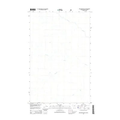
2014 Map of Red Mountain OE N
USGS Topo · Published 2014About this map
Canada marks the northern boundary of this 2014 survey, which documents the remote drainage systems flowing across the international border between Montana and British Columbia. The landscape is defined by the headwaters of Gold Creek, which winds through the northern section, and the tributary networks of Purcell Cr and Linklater Cr in the center. These watercourses represent the primary geographic features of a territory characterized by significant elevation changes and deep mountain valleys. In the southern reach of the quadrangle, Sink Cr drains toward the border, illustrating the complex hydrologic patterns of the northern Rockies. This modern topographic study, produced with data from the U.S. Geological Survey and the U.S. Forest Service, provides a clear view of the natural terrain and forest roads before subsequent shifts in land management or environmental changes.
Find a feature on this map
5 named features on this map. Tap any name to fly to it.
Don’t see what you’re looking for? This feature index may not catch every label — zoom into the map to look around manually.
Map Details
Editions of this 2014 Red Mountain OE N Map
This is the sole edition of this map. No revisions or reprints were ever made.
Other maps of this area

1957 · Kalispell
USGS Topo · 1:250,000

1960 · Kalispell
USGS Topo · 1:250,000

1961 · Kalispell
USGS Topo · 1:250,000

1963 · Rexford
USGS Topo · 1:24,000

1963 · Robinson Mountain
USGS Topo · 1:24,000

1963 · Red Mountain
USGS Topo · 1:24,000

1979 · Yaak River
USGS Topo · 1:100,000
1983 · Rexford
USGS Topo · 1:24,000
1997 · Robinson Mountain
USGS Topo · 1:24,000
1997 · Rexford
USGS Topo · 1:24,000