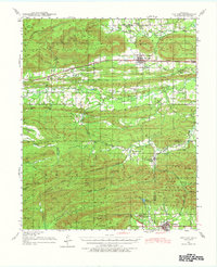
1940 Map of Red Oak
USGS Topo · Published 1977About this map
Winding Stair Mountain and the surrounding Choctaw Country terrain dominate this survey, which captures the region during a period of transition in the late 1930s. The northern corridor follows the Chicago Rock Island and Pacific railroad through the settlements of Panola and Red Oak, while the southern reaches center on Talihina and the State Sanitorium. The landscape is a network of named ridges like Baker Mountain and Granny Graham Mountain, cut by the winding Fourche Maline river system. Rural community life is visible through a high density of country institutions, including the Dunlap Center Sch, Salonia Sch, and Hulsey Prairie Sch. The southern portion of the map transitions into the Ouachita National Forest, where the topography becomes increasingly complex around Gobblers Knob and the Devils Hollow drainage.
Find a feature on this map
77 named features on this map. Tap any name to fly to it.
Don’t see what you’re looking for? This feature index may not catch every label — zoom into the map to look around manually.
Map Details
Editions of this 1940 Red Oak Map
2 editions found

Other maps of this area

1900 · Sansbois
USGS Topo · 1:125,000

1900 · Sallisaw
USGS Topo · 1:125,000

1900 · Winding Stair
USGS Topo · 1:125,000

1901 · Tuskahoma
USGS Topo · 1:125,000

1908 · Tuskahoma
USGS Topo · 1:125,000

1909 · Tuskahoma
USGS Topo · 1:125,000

1909 · Winding Stair
USGS Topo · 1:125,000

1909 · Sans Bois
USGS Topo · 1:125,000

1911 · Sallisaw
USGS Topo · 1:125,000

1911 · Sansbois
USGS Topo · 1:125,000