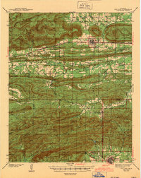
1943 Map of Red Oak
USGS Topo · Published 1943About this map
Talihina and Red Oak anchor this 1943 survey, which illustrates the complex mountain and valley geography of the Ouachita National Forest in southeastern Oklahoma. The landscape is defined by massive ridges such as Winding Stair Mountain and Baker Mountain, which dictate the paths of early transportation networks. The northern valley carries the Chicago Rock Island and Pacific railroad through settlements like Panola and Maline, while the southern corridor is served by the St Louis San Francisco line. The map captures a high density of rural social infrastructure, from the State Sanatorium and Us Hospital near Talihina to numerous remote educational outposts like Boggy Sch and Peachland Sch. These labels reveal a populated backcountry before the mid-century consolidation of rural school districts, offering a look at the dispersed communities of Latimer Co and Le Flore Co.
Find a feature on this map
71 named features on this map. Tap any name to fly to it.
Don’t see what you’re looking for? This feature index may not catch every label — zoom into the map to look around manually.
Map Details
Editions of this 1943 Red Oak Map
2 editions found

Other maps of this area

1900 · Sansbois
USGS Topo · 1:125,000

1900 · Sallisaw
USGS Topo · 1:125,000

1900 · Winding Stair
USGS Topo · 1:125,000

1901 · Tuskahoma
USGS Topo · 1:125,000

1908 · Tuskahoma
USGS Topo · 1:125,000

1909 · Tuskahoma
USGS Topo · 1:125,000

1909 · Winding Stair
USGS Topo · 1:125,000

1909 · Sans Bois
USGS Topo · 1:125,000

1911 · Sallisaw
USGS Topo · 1:125,000

1911 · Sansbois
USGS Topo · 1:125,000