
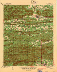
1943 Map of Red Oak
USGS Topo · Published 1943About this map
The Sans Bois Mountains and the northern reaches of the Ouachita National Forest define the rugged topography of this 1943 survey of eastern Oklahoma. The map documents a landscape deeply shaped by the St. Louis San Francisco and Rock Island and Pacific railroads, which facilitated the growth of towns like Red Oak, Talihina, and Panola. The survey was conducted just before the United States entered World War II, capturing the rural community structure at a time when small school districts like Dunlap Center Sch and Salonia Sch were still the social hubs of the ridges and valleys.
Find a feature on this map
79 named features on this map. Tap any name to fly to it.
Don’t see what you’re looking for? This feature index may not catch every label — zoom into the map to look around manually.
Map Details
Editions of this 1943 Red Oak Map
2 editions found
Other maps of this area

1900 · Sansbois
USGS Topo · 1:125,000

1900 · Sallisaw
USGS Topo · 1:125,000

1900 · Winding Stair
USGS Topo · 1:125,000

1901 · Tuskahoma
USGS Topo · 1:125,000

1908 · Tuskahoma
USGS Topo · 1:125,000

1909 · Tuskahoma
USGS Topo · 1:125,000

1909 · Winding Stair
USGS Topo · 1:125,000

1909 · Sans Bois
USGS Topo · 1:125,000

1911 · Sallisaw
USGS Topo · 1:125,000

1911 · Sansbois
USGS Topo · 1:125,000