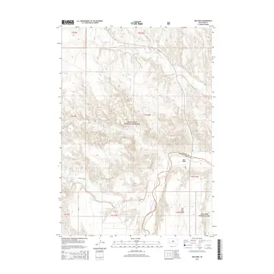
2015 Map of Red Shirt
USGS Topo · Published 2015About this map
Red Shirt and the adjacent Red Shirt Table anchor this portion of Oglala Lakota County, where the plains meet the distinct topographical breaks of the Badlands National Park. The landscape is defined by the convergence of several drainages, including Battle Cr, Red Shirt Cr, and French Cr, which carve through the Buffalo Gap National Grassland. The map illustrates a remote section of the Wounded Knee District, showing the transition from the high, flat plateaus to the deeply eroded creek beds. Local transportation is limited to routes like Bison Ln and E French Creek Rd, which provide access to the dispersed ranching and tribal lands characteristic of this region. The interface between the protected grassland and the national park highlights the preservation of the area's natural landforms and traditional geography.
Find a feature on this map
20 named features on this map. Tap any name to fly to it.
Don’t see what you’re looking for? This feature index may not catch every label — zoom into the map to look around manually.
Map Details
Editions of this 2015 Red Shirt Map
This is the sole edition of this map. No revisions or reprints were ever made.
Other maps of this area

1894 · Hermosa
USGS Topo · 1:125,000

1901 · Hermosa
USGS Topo · 1:125,000

1951 · Fairburn SE
USGS Topo · 1:24,000

1951 · Red Shirt
USGS Topo · 1:24,000

1951 · Red Shirt NE
USGS Topo · 1:24,000

1951 · Red Shirt SW
USGS Topo · 1:24,000

1951 · Cuny Table West
USGS Topo · 1:24,000

1953 · Hermosa SE
USGS Topo · 1:24,000

1953 · Folsom
USGS Topo · 1:24,000

1953 · Caputa SW
USGS Topo · 1:24,000