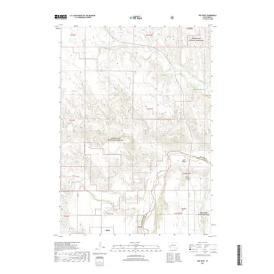
2017 Map of Red Shirt
USGS Topo · Published 2017About this map
Red Shirt and the surrounding rangeland of the Oglala Lakota nation are defined by the winding course of the Cheyenne River and its numerous tributaries. This landscape, dominated by the Buffalo Gap National Grassland, reveals a sparse but significant settlement pattern centered near the Custer and Oglala Lakota county line. The community of Red Shirt is situated along BIA Hwy 41, adjacent to the Seventh - day Adventist Church Cem, which serves as a central landmark for local genealogy and history. To the south, the dramatic elevation of Red Shirt Table overlooks the drainages of French Cr and Red Shirt Cr. The southeastern corner of the map touches the edge of Badlands National Park, where Cedar Cr begins to carve through the high plains, illustrating the intersection of federal protected lands and tribal territory.
Find a feature on this map
24 named features on this map. Tap any name to fly to it.
Don’t see what you’re looking for? This feature index may not catch every label — zoom into the map to look around manually.
Map Details
Editions of this 2017 Red Shirt Map
This is the sole edition of this map. No revisions or reprints were ever made.
Other maps of this area

1894 · Hermosa
USGS Topo · 1:125,000

1901 · Hermosa
USGS Topo · 1:125,000

1951 · Fairburn SE
USGS Topo · 1:24,000

1951 · Red Shirt
USGS Topo · 1:24,000

1951 · Red Shirt NE
USGS Topo · 1:24,000

1951 · Red Shirt SW
USGS Topo · 1:24,000

1951 · Cuny Table West
USGS Topo · 1:24,000

1953 · Hermosa SE
USGS Topo · 1:24,000

1953 · Folsom
USGS Topo · 1:24,000

1953 · Caputa SW
USGS Topo · 1:24,000