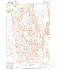
1951 Map of Red Shirt SW
USGS Topo · Published 1979About this map
Pine Ridge Indian Reservation land dominates this landscape, characterized by the dramatic transition between high tablelands and the winding valley of the Cheyenne River. The river forms a natural northern limit, with the Reservation Boundary following its course before cutting across the high plains. This map captures a rugged topography where significant plateaus like Squaw-Humper Table and Little Squaw-Humper Table rise above the surrounding terrain. Drainage patterns are defined by the Little Squaw-Humper Creek and Cedar Creek, which carve deep into the Pine Ridge escarpment. The mapping reflects a post-war effort for the development of the Missouri River Basin, documenting the border between Custer and Shannon counties before the latter was renamed Oglala Lakota County. The terrain is notably sparse of structures, emphasizing the natural divisions of the Red Shirt Table region.
Find a feature on this map
10 named features on this map. Tap any name to fly to it.
Don’t see what you’re looking for? This feature index may not catch every label — zoom into the map to look around manually.
Map Details
Editions of this 1951 Red Shirt SW Map
2 editions found
Other maps of this area

1894 · Hermosa
USGS Topo · 1:125,000

1896 · Oelrichs
USGS Topo · 1:125,000

1900 · Oelrichs
USGS Topo · 1:125,000

1901 · Hermosa
USGS Topo · 1:125,000

1951 · Fairburn SE
USGS Topo · 1:24,000

1951 · Red Shirt
USGS Topo · 1:24,000

1951 · Willow Creek NW
USGS Topo · 1:24,000

1951 · Willow Creek NE
USGS Topo · 1:24,000

1951 · Red Shirt NE
USGS Topo · 1:24,000

1951 · Red Shirt SW
USGS Topo · 1:24,000