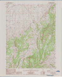
1985 Map of Red Spring
USGS Topo · Published 1986About this map
Red Spring serves as a vital water source in this high-desert landscape of Elko County, marking a rare point of reliable hydration at the foot of the rising terrain. The map captures an arid expanse defined by broad basins and high ridges, where survival depends on localized landmarks like Indian Well and various Stock Tanks. To the north, the geography opens into the wide reaches of Dixie Flats and White Flats, separated by complex drainages and the prominent Cedar Ridge. The presence of Crane Springs Canyon suggests the seasonal movement of water and likely livestock through this remote territory. This provisional survey is particularly useful for understanding the ranching infrastructure of the 1980s, documenting the essential wells and springs that made the high Nevada basins habitable for cattle and land managers.
Find a feature on this map
9 named features on this map. Tap any name to fly to it.
Don’t see what you’re looking for? This feature index may not catch every label — zoom into the map to look around manually.
Map Details
Editions of this 1985 Red Spring Map
This is the sole edition of this map. No revisions or reprints were ever made.
Other maps of this area

1934 · Jiggs
USGS Topo · 1:125,000

1937 · Jiggs
USGS Topo · 1:125,000

1952 · Dixie Flats
USGS Topo · 1:62,500

1955 · Elko
USGS Topo · 1:250,000

1956 · Robinson Mtn
USGS Topo · 1:62,500

1958 · Elko
USGS Topo · 1:250,000

1959 · Jiggs
USGS Topo · 1:62,500

1962 · Elko
USGS Topo · 1:250,000

1962 · Lee
USGS Topo · 1:62,500

1965 · Elko
USGS Topo · 1:250,000