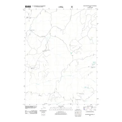
2011 Map of Red Spur Mountain
USGS Topo · Published 2011About this map
Baxter Sawmill and the high-elevation drainages of Red Spur Mountain define this section of the northern Wasatch Range. The landscape is characterized by a complex network of seasonal and perennial water sources, including Otter Creek and Rock Creek, which feed into localized impoundments like Lodgepole Reservoir and Green Fork Reservoir. These water management features, alongside named springs such as Nebeker Spring and Campground Spring, indicate the historical importance of water rights and livestock grazing in the high valleys. The topography is marked by several distinct basins and flats, including Elk Valley and Little Strawberry Valley, while the presence of Basin Beaver Ponds suggests a dynamic riparian environment. This 2011 survey highlights the intersection of forest resource extraction and natural hydrology within the rugged backcountry of Cache County.
Find a feature on this map
26 named features on this map. Tap any name to fly to it.
Don’t see what you’re looking for? This feature index may not catch every label — zoom into the map to look around manually.
Map Details
Editions of this 2011 Red Spur Mountain Map
This is the sole edition of this map. No revisions or reprints were ever made.
Other maps of this area

1912 · Randolph
USGS Topo · 1:125,000

1914 · Logan
USGS Topo · 1:125,000

1916 · Logan
USGS Topo · 1:125,000

1949 · Boulter Mts
USGS Topo · 1:24,000

1954 · Ogden
USGS Topo · 1:250,000

1958 · Ogden
USGS Topo · 1:250,000

1960 · Ogden
USGS Topo · 1:250,000

1969 · Boulder Mtn
USGS Topo · 1:24,000
1969 · Birch Creek Reservoirs
USGS Topo · 1:24,000
1969 · Hardware Ranch
USGS Topo · 1:24,000