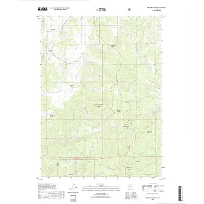
2020 Map of Red Spur Mountain
USGS Topo · Published 2020About this map
Red Spur Mtn rises near the border of Cache Co and Rich Co, anchoring a landscape within the Cache National Forest defined by its complex hydrology and timber history. The presence of Baxter Sawmill and Baxter Sawmill Rd near the Monte Cristo Range points to the area's legacy of forest resource management. This terrain is marked by a vast network of water sources, from high-elevation basins like Bug Lake and Basin Beaver Ponds to engineered catchments such as Fence Reservoir, Lodgepole Reservoir, and Green Fork Reservoir. The map illustrates a remote wilderness managed for both recreation and utility, with specialized trails like the Sinks Trail-Winter Sport and the Curtis Creek Snowmobile route threading through Strawberry Valley and Elk Valley. This survey captures the modern state of these protected lands, highlighting the numerous springs and overlooks, including Rock Creek Overlook, that define the geography of the northern Wasatch area.
Find a feature on this map
61 named features on this map. Tap any name to fly to it.
Don’t see what you’re looking for? This feature index may not catch every label — zoom into the map to look around manually.
Map Details
Editions of this 2020 Red Spur Mountain Map
This is the sole edition of this map. No revisions or reprints were ever made.
Other maps of this area

1912 · Randolph
USGS Topo · 1:125,000

1914 · Logan
USGS Topo · 1:125,000

1916 · Logan
USGS Topo · 1:125,000

1949 · Boulter Mts
USGS Topo · 1:24,000

1954 · Ogden
USGS Topo · 1:250,000

1958 · Ogden
USGS Topo · 1:250,000

1960 · Ogden
USGS Topo · 1:250,000

1969 · Boulder Mtn
USGS Topo · 1:24,000
1969 · Birch Creek Reservoirs
USGS Topo · 1:24,000
1969 · Hardware Ranch
USGS Topo · 1:24,000