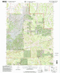
1998 Map of Red Spur Mountain
USGS Topo · Published 2001About this map
Strawberry Valley and the surrounding high country of the Cache National Forest are documented here in late-twentieth-century detail. The landscape is defined by its water management and agricultural history, seen in the numerous managed points like Deer Lick Reservoir, Ferice Reservoir, and the Basin Beaver Ponds. This territory, straddling the Cache and Rich County line, reveals layers of early-to-mid-century land use, including the Baxter Sawmill (Site) in the southern reaches. The survey captures the complex drainage systems of Curtis Creek and Rock Creek, alongside the operational Hardware Ranch Facility. Notable geological features such as Red Spur Mtn and the steep incisions of Lodgepole Canyon and North Gorge illustrate the character of the Logan and Ogden Ranger Districts. These records are invaluable for tracing local livestock ranching infrastructure and the evolution of forest management in northern Utah.
Find a feature on this map
55 named features on this map. Tap any name to fly to it.
Don’t see what you’re looking for? This feature index may not catch every label — zoom into the map to look around manually.
Map Details
Editions of this 1998 Red Spur Mountain Map
This is the sole edition of this map. No revisions or reprints were ever made.
Other maps of this area

1912 · Randolph
USGS Topo · 1:125,000

1914 · Logan
USGS Topo · 1:125,000

1916 · Logan
USGS Topo · 1:125,000

1949 · Boulter Mts
USGS Topo · 1:24,000

1954 · Ogden
USGS Topo · 1:250,000

1958 · Ogden
USGS Topo · 1:250,000

1960 · Ogden
USGS Topo · 1:250,000

1969 · Boulder Mtn
USGS Topo · 1:24,000
1969 · Birch Creek Reservoirs
USGS Topo · 1:24,000
1969 · Hardware Ranch
USGS Topo · 1:24,000