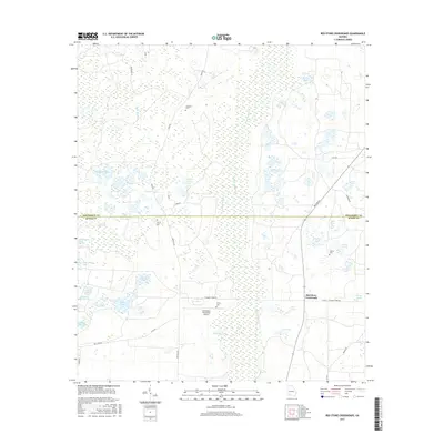
2017 Map of Red Store Crossroads
USGS Topo · Published 2017About this map
Red Store Crossroads serves as a central waypoint in a landscape defined by the drainage basins of Cooleewahee Cr and Alligator Cr. This area of Southwest Georgia is characterized by a remarkable density of limestone sinks and ponds, such as Big Cypress Lake, Windmill Pond, and Alligator Pond, which suggest the complex subterranean karst topography typical of the region. The map reveals a pattern of rural land use centered around large holdings, most notably the Pinebloom Plantation Airport. Scattered family and community history is preserved in small burial sites across the terrain, including Trinity Cem, Clifton Cem, and Tarva Cem. Roadways like Newton Rd and Colquitt Ford Rd connect these isolated landmarks across the transition from Dougherty to Baker counties.
Find a feature on this map
44 named features on this map. Tap any name to fly to it.
Don’t see what you’re looking for? This feature index may not catch every label — zoom into the map to look around manually.
Map Details
Editions of this 2017 Red Store Crossroads Map
This is the sole edition of this map. No revisions or reprints were ever made.
Other maps of this area

1953 · Dothan
USGS Topo · 1:250,000

1954 · Dothan
USGS Topo · 1:250,000

1955 · Dothan
USGS Topo · 1:250,000

1956 · Albany West
USGS Topo · 1:24,000

1956 · Baconton
USGS Topo · 1:62,500

1956 · Newton
USGS Topo · 1:62,500

1956 · Sasser
USGS Topo · 1:62,500

1956 · Albany
USGS Topo · 1:62,500

1973 · Pretoria
USGS Topo · 1:24,000
1973 · Holt
USGS Topo · 1:24,000