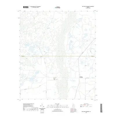
2020 Map of Red Store Crossroads
USGS Topo · Published 2020About this map
Red Store Crossroads anchors this low-lying landscape along the border of Baker and Dougherty Counties, where a complex network of wetlands and creeks defines the local geography. The area is characterized by an extensive system of named ponds and sloughs, including Windmill Pond, Halls Slough, and Big Cypress Lake, which feed into larger arteries like Coheelee Cr and Alligator Cr. This saturation of the land suggests a rural economy historically tied to the water table and specialized land use, such as that seen at the Pinebloom Plantation Airport. Genealogists and local historians will find several established burial sites scattered across the countryside, such as Trinity Cem, Clifton Cem, and Whitehill Cem. The road network, featuring routes like Colquitt Ford Rd and Newton Rd, connects these remote homesteads and landmarks through the cypress-heavy terrain typical of southwest Georgia.
Find a feature on this map
42 named features on this map. Tap any name to fly to it.
Don’t see what you’re looking for? This feature index may not catch every label — zoom into the map to look around manually.
Map Details
Editions of this 2020 Red Store Crossroads Map
This is the sole edition of this map. No revisions or reprints were ever made.
Other maps of this area

1953 · Dothan
USGS Topo · 1:250,000

1954 · Dothan
USGS Topo · 1:250,000

1955 · Dothan
USGS Topo · 1:250,000

1956 · Albany West
USGS Topo · 1:24,000

1956 · Baconton
USGS Topo · 1:62,500

1956 · Newton
USGS Topo · 1:62,500

1956 · Sasser
USGS Topo · 1:62,500

1956 · Albany
USGS Topo · 1:62,500

1973 · Pretoria
USGS Topo · 1:24,000
1973 · Holt
USGS Topo · 1:24,000