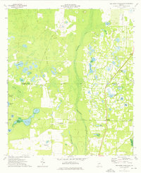
1974 Map of Red Store Crossroads
USGS Topo · Published 1976About this map
Cooleewahee Creek dominates the center of this rural landscape, carving a wide swampy path through southwest Georgia in the mid-1970s. This survey captures a moment when the region was characterized by scattered homesteads and significant water features, from large basins like Halls Pond and Long Pond to smaller named landmarks such as Alligator Pond and Windmill Pond. The settlement pattern centers on the namesake Red Store Crossroads, with the nearby Chapel Hill Ch and several family-named burial grounds like Whitehill Cem, Tarva Cem, and Trinity Cem providing essential markers for genealogical research. Aviation history is noted by the Brent-Young Landing Strip, while the Dougherty Co Baker Co boundary bisects the varied terrain of the Piney Woods Branch and Reynolds Swamp.
Find a feature on this map
38 named features on this map. Tap any name to fly to it.
Don’t see what you’re looking for? This feature index may not catch every label — zoom into the map to look around manually.
Map Details
Editions of this 1974 Red Store Crossroads Map
This is the sole edition of this map. No revisions or reprints were ever made.
Other maps of this area

1953 · Dothan
USGS Topo · 1:250,000

1954 · Dothan
USGS Topo · 1:250,000

1955 · Dothan
USGS Topo · 1:250,000

1956 · Albany West
USGS Topo · 1:24,000

1956 · Baconton
USGS Topo · 1:62,500

1956 · Newton
USGS Topo · 1:62,500

1956 · Sasser
USGS Topo · 1:62,500

1956 · Albany
USGS Topo · 1:62,500

1973 · Pretoria
USGS Topo · 1:24,000
1973 · Holt
USGS Topo · 1:24,000