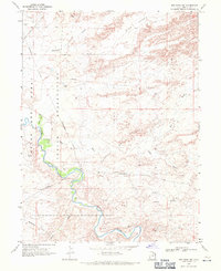
1968 Map of Red Wash SW
USGS Topo · Published 1971About this map
The White River carves a winding path through the heart of the Uintah and Ouray Indian Reservation in this late 1960s survey. The landscape is defined by the heavy infrastructure of the energy industry, with the Chapita Wells Gas Field and Wonsits-Wonsits Valley Oil Field sprawling across the desert terrain. A complex network of an Aboveground Pipeline and various Jeep Trails crisscross the area, connecting numerous sites marked as Oil Wells, Gas Wells, and Drill Holes. Natural landmarks like the prominent Ship Rock and the riparian area of Chapita Grove provide contrast to the industrial development. The topographic detail captures the transition from the high Glen Bench down into the rugged drainage systems of Coyote Wash and Antelope Draw, illustrating how the mid-century petroleum boom transformed this corner of Uintah County.
Find a feature on this map
17 named features on this map. Tap any name to fly to it.
Don’t see what you’re looking for? This feature index may not catch every label — zoom into the map to look around manually.
Map Details
Editions of this 1968 Red Wash SW Map
This is the sole edition of this map. No revisions or reprints were ever made.
Other maps of this area

1885 · East Tavaputs
USGS Topo · 1:250,000

1885 · Ashley
USGS Topo · 1:250,000

1907 · Jensen
USGS Topo · 1:125,000

1910 · Jensen
USGS Topo · 1:125,000

1917 · Vernal
USGS Topo · 1:125,000

1954 · Vernal
USGS Topo · 1:250,000

1956 · Grand Junction
USGS Topo · 1:250,000

1958 · Vernal
USGS Topo · 1:250,000

1959 · Grand Junction
USGS Topo · 1:250,000

1960 · Vernal
USGS Topo · 1:250,000