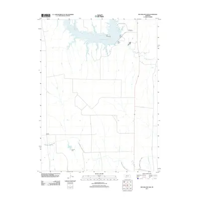
2011 Map of Red Willow Dam
USGS Topo · Published 2011About this map
Hugh Butler Lake dominates the northern landscape of this Red Willow County region, created by the engineering of the Red Willow Dam. This reservoir and its surrounding recreational sites, including the Indian Point Campground and Willow View Campground, reflect the significance of water management and outdoor tourism in this part of Nebraska. Further south, the legacy of early 20th-century irrigation is visible through the intricate paths of the Culbertson Extension Canal and the Culbertson Canal, which divert water toward agricultural fields from the Red Willow Creek drainage.
Find a feature on this map
17 named features on this map. Tap any name to fly to it.
Don’t see what you’re looking for? This feature index may not catch every label — zoom into the map to look around manually.
Map Details
Editions of this 2011 Red Willow Dam Map
This is the sole edition of this map. No revisions or reprints were ever made.
Other maps of this area

1954 · McCook
USGS Topo · 1:250,000

1956 · Quick NE
USGS Topo · 1:24,000

1957 · McCook
USGS Topo · 1:250,000

1958 · McCook
USGS Topo · 1:250,000

1970 · Red Willow Dam
USGS Topo · 1:24,000

1970 · Quick
USGS Topo · 1:24,000
1970 · Culbertson
USGS Topo · 1:24,000

1970 · McCook West
USGS Topo · 1:24,000

1970 · Burger Canyon SE
USGS Topo · 1:24,000

1970 · Quick SE
USGS Topo · 1:24,000