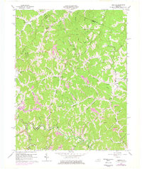
1962 Map of Redbush
USGS Topo · Published 1978About this map
Gas and Oil Field operations dominate the topography of northern Johnson County, where a dense network of wells and pipelines marks the intersection of rural life and industrial extraction. Small creek-side settlements like Redbush and Keaton serve as hubs for the surrounding hollows, connected by winding routes like KY 172. The landscape is deeply incised by waterways such as Paint Creek and Blaine Creek, which create natural landmarks including the Natural Bridge and Paint Cliff. Local educational and spiritual centers are well-documented, with the Burchett Flat Sch and Old Bethel Ch providing vital points of reference for genealogists. In the southern portions of the map, the shift toward coal extraction is evident at the Strip Mine near Maddick Br, illustrating the diverse energy resources being tapped during this era of Kentucky's history.
Find a feature on this map
74 named features on this map. Tap any name to fly to it.
Don’t see what you’re looking for? This feature index may not catch every label — zoom into the map to look around manually.
Map Details
Editions of this 1962 Redbush Map
3 editions found
Other maps of this area

1886 · Prestonsburg
USGS Topo · 1:125,000

1889 · Salyersville
USGS Topo · 1:125,000

1891 · Salyersville
USGS Topo · 1:125,000

1892 · Prestonsburg
USGS Topo · 1:125,000

1899 · Salyersville
USGS Topo · 1:125,000

1903 · Kenova
USGS Topo · 1:125,000

1904 · Kenova
USGS Topo · 1:125,000

1915 · Paintsville
USGS Topo · 1:48,000

1917 · Paintsville
USGS Topo · 1:62,500

1950 · Isonville
USGS Topo · 1:24,000