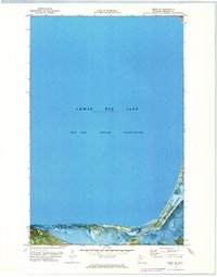
1972 Map of Redby NE
USGS Topo · Published 1974About this map
Red Lake Indian Reservation dominates this 1970s orthophotomap, showing the expansive waters and shoreline of Lower Red Lake. This specialized survey combines traditional topographic contours with aerial imagery, providing a precise record of the shoreline and hydrology of Beltrami County. The landscape is defined by the southeastern reach of the lake, where the Blackduck River and Hay Creek discharge into the reservoir pool.
Find a feature on this map
5 named features on this map. Tap any name to fly to it.
Don’t see what you’re looking for? This feature index may not catch every label — zoom into the map to look around manually.
Map Details
Editions of this 1972 Redby NE Map
This is the sole edition of this map. No revisions or reprints were ever made.
Other maps of this area

1919 · Fox
USGS Topo · 1:62,500

1919 · Quiring
USGS Topo · 1:62,500

1919 · Ponemah
USGS Topo · 1:62,500

1943 · Ponemah
USGS Topo · 1:62,500

1954 · Bemidji
USGS Topo · 1:250,000

1954 · Roseau
USGS Topo · 1:250,000

1957 · Roseau
USGS Topo · 1:250,000

1957 · Bemidji
USGS Topo · 1:250,000

1958 · Bemidji
USGS Topo · 1:250,000

1958 · Roseau
USGS Topo · 1:250,000