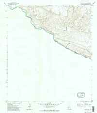
1971 Map of Redford SE
USGS Topo · Published 1974About this map
The Rio Grande carves a deep path through the Big Bend region, serving as the international boundary between Texas and Mexico. This 1971 survey captures a remote stretch of Presidio County characterized by dramatic vertical relief and significant geological features. The landscape is defined by its drainage patterns, most notably where Colorado Canyon, Closed Canyon, and Rancherias Canyon intersect the river's course. These canyons highlight the erosive power of seasonal water in an arid environment, creating a labyrinth of steep terrain along the border.
Find a feature on this map
11 named features on this map. Tap any name to fly to it.
Don’t see what you’re looking for? This feature index may not catch every label — zoom into the map to look around manually.
Map Details
Editions of this 1971 Redford SE Map
2 editions found
Other maps of this area

1896 · Polvo
USGS Topo · 1:125,000

1903 · Terlingua
USGS Topo · 1:125,000

1904 · Terlingua
USGS Topo · 1:125,000

1931 · Lajitas
USGS Topo · 1:62,500

1959 · Emory Peak
USGS Topo · 1:250,000

1959 · Presidio
USGS Topo · 1:250,000

1965 · Presidio
USGS Topo · 1:250,000

1965 · Emory Peak
USGS Topo · 1:250,000
1971 · Redford SE
USGS Topo · 1:24,000
1971 · Agua Adentro Mountain
USGS Topo · 1:24,000