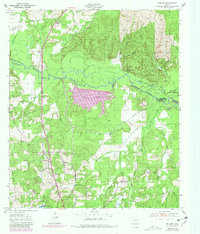
1950 Map of Redland
USGS Topo · Published 1981About this map
The Angelina River meanders across the East Texas landscape, forming a natural boundary between Nacogdoches and Angelina Counties. This area was undergoing significant hydrological changes at the time of this survey, with the Sam Rayburn Reservoir and Kurth Lake altering the traditional drainage patterns of creeks like Paper Mill Creek and Mill Creek. A network of infrastructure, including an Aqueduct and the Lufkin Water Plant, underscores the region's industrial and municipal development during the mid-20th century.
Find a feature on this map
33 named features on this map. Tap any name to fly to it.
Don’t see what you’re looking for? This feature index may not catch every label — zoom into the map to look around manually.
Map Details
Editions of this 1950 Redland Map
4 editions found

Other maps of this area

1949 · Lufkin
USGS Topo · 1:62,500

1949 · Platt
USGS Topo · 1:24,000

1949 · Clawson
USGS Topo · 1:24,000

1949 · Lufkin
USGS Topo · 1:24,000

1949 · Huntington
USGS Topo · 1:24,000

1949 · Keltys
USGS Topo · 1:24,000

1950 · Platt
USGS Topo · 1:24,000

1950 · Keltys
USGS Topo · 1:24,000

1950 · Lufkin
USGS Topo · 1:24,000

1950 · Clawson
USGS Topo · 1:24,000