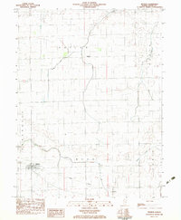
1982 Map of Redmon
USGS Topo · Published 1983About this map
Redmon serves as the primary settlement in this corner of Edgar County, oriented along the Central rail line. The landscape is defined by the headwaters and meandering courses of Brouilletts Cr and its South Fork, alongside the drainage of Catfish Creek and Sugar Creek. These waterways dictate the local topography and historical agricultural boundaries of townships like Buck and Embarrass. Smaller locales such as Garland and Mays dot the region, connected by a network of rural roads that cross areas designated as Prairie and Special. The map reflects a classic Illinois prairie-to-creek transition, where the grid of human settlement meets the winding natural paths of the local stream systems.
Find a feature on this map
14 named features on this map. Tap any name to fly to it.
Don’t see what you’re looking for? This feature index may not catch every label — zoom into the map to look around manually.
Map Details
Editions of this 1982 Redmon Map
This is the sole edition of this map. No revisions or reprints were ever made.
Other maps of this area

1946 · Kansas
USGS Topo · 1:62,500

1947 · Ridge Farm
USGS Topo · 1:62,500

1947 · Paris
USGS Topo · 1:62,500

1949 · Kansas
USGS Topo · 1:62,500

1949 · Paris
USGS Topo · 1:62,500

1953 · Indianapolis
USGS Topo · 1:250,000

1956 · Indianapolis
USGS Topo · 1:250,000

1956 · Newman
USGS Topo · 1:62,500

1957 · Indianapolis
USGS Topo · 1:250,000

1962 · Indianapolis
USGS Topo · 1:250,000