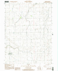
1998 Map of Redmon
USGS Topo · Published 2002About this map
The village of Redmon stands as the primary settlement in this western Edgar County landscape, situated at the crossroads of local commerce and agriculture. The terrain is defined by a sophisticated water management system designed to support fertile prairie farmland, featuring the Special Ditch, Shiloh Ditch, and Ditch No 3. These engineered waterways augment natural drainages like Catfish Creek and Sugar Creek, which wind through the township sections. Smaller hamlets such as Garland to the north and Mays at the southern edge provide context for late 20th-century rural life and local genealogy. The eastern portion of the sheet is marked by the riparian corridors of Brouilletts Cr and the South Fork Brouilletts Creek, where the land begins to roll toward the Indiana border.
Find a feature on this map
18 named features on this map. Tap any name to fly to it.
Don’t see what you’re looking for? This feature index may not catch every label — zoom into the map to look around manually.
Map Details
Editions of this 1998 Redmon Map
This is the sole edition of this map. No revisions or reprints were ever made.
Other maps of this area

1946 · Kansas
USGS Topo · 1:62,500

1947 · Ridge Farm
USGS Topo · 1:62,500

1947 · Paris
USGS Topo · 1:62,500

1949 · Kansas
USGS Topo · 1:62,500

1949 · Paris
USGS Topo · 1:62,500

1953 · Indianapolis
USGS Topo · 1:250,000

1956 · Indianapolis
USGS Topo · 1:250,000

1956 · Newman
USGS Topo · 1:62,500

1957 · Indianapolis
USGS Topo · 1:250,000

1962 · Indianapolis
USGS Topo · 1:250,000