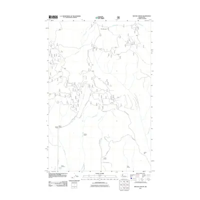
2011 Map of Reecer Canyon
USGS Topo · Published 2011About this map
Table Mountain dominates the northern portion of this Kittitas County landscape, where a dense network of forest service roads like Table Mountain Rd and NFD 116 Rd weave through the high terrain. The map details a rugged drainage system defined by Reecer Canyon and Currier Canyon, with numerous smaller ravines such as Robbins Canyon and Snag Canyon carving the slopes. Human activity is marked by isolated landmarks like Riders Cabin and infrastructure such as the Reimer Pond Dam near the southern boundary. This 2011 survey serves as a precise record of the complex topography and water sources in the region, including Garrison Spring, Barrel Spring, and the headwaters of Reecer Creek and Jones Creek.
Find a feature on this map
42 named features on this map. Tap any name to fly to it.
Don’t see what you’re looking for? This feature index may not catch every label — zoom into the map to look around manually.
Map Details
Editions of this 2011 Reecer Canyon Map
This is the sole edition of this map. No revisions or reprints were ever made.
Other maps of this area

1897 · Mount Stuart
USGS Topo · 1:125,000

1902 · Mount Stuart
USGS Topo · 1:125,000

1913 · Wenatchee
USGS Topo · 1:62,500

1915 · Wenatchee
USGS Topo · 1:62,500

1920 · Colockum Pass
USGS Topo · 1:125,000

1922 · Colockum Pass
USGS Topo · 1:125,000

1957 · Wenatchee
USGS Topo · 1:250,000

1958 · Thorp
USGS Topo · 1:24,000

1958 · Thorp
USGS Topo · 1:62,500
1958 · Ellensburg North
USGS Topo · 1:24,000