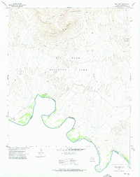
1971 Map of Reed Camp
USGS Topo · Published 1974About this map
The Rio Grande carves a sharp, winding international boundary through this remote desert landscape within Big Bend National Park. This 1971 survey illustrates a territory of isolated riverfront outposts and rugged topography, where the massive Chisos Mountains and the distinctive Punta De La Sierra dominate the northern skyline. The river's edge is marked by a series of small, significant settlements and camps including Johnson Ranch, which features a Cem and Ruins, as well as Reed Camp and Woodsons. These locations, along with Jewels Camp and Pettits, hint at the lived history of the borderlands before modern park management fully transitioned the area to wilderness. Connectivity is limited to ancient paths like the Dominguez Spring Trail, which provides access to vital water sources such as Dominguez Spring in an otherwise arid terrain.
Find a feature on this map
20 named features on this map. Tap any name to fly to it.
Don’t see what you’re looking for? This feature index may not catch every label — zoom into the map to look around manually.
Map Details
Editions of this 1971 Reed Camp Map
This is the sole edition of this map. No revisions or reprints were ever made.
Other maps of this area

1903 · Chisos Mountains
USGS Topo · 1:125,000

1905 · Chisos Mountains
USGS Topo · 1:125,000

1959 · Emory Peak
USGS Topo · 1:250,000

1965 · Emory Peak
USGS Topo · 1:250,000

1971 · Glenn Spring
USGS Topo · 1:24,000

1971 · Cerro Castellan
USGS Topo · 1:24,000
1971 · Smoky Creek
USGS Topo · 1:24,000
1971 · Emory Peak
USGS Topo · 1:24,000

1985 · Chisos Mountains
USGS Topo · 1:100,000
1997 · Emory Peak
USGS Topo · 1:24,000