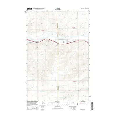
2014 Map of Reed Point
USGS Topo · Published 2014About this map
The Yellowstone River cuts through the heart of this landscape, serving as a boundary between the higher basin terrain to the north and the complex drainage networks to the south. Reed Point is the primary settlement, situated along the river's southern bank near the Reedpoint Bridge. This area is characterized by significant topographical shifts, from the prominent Monument Butte in the northeast to the various coulees and creek beds that feed into the main waterway. Local infrastructure is anchored by historical routes and water management systems, including the Reed Point Ditch and trails like the Overland Bridge Trl. Evidence of established community life is found at the Reed Point Cem, while the southern portion of the map is defined by the headwaters of the N-Fork Countryman Cr and S Fork Countryman Cr.
Find a feature on this map
38 named features on this map. Tap any name to fly to it.
Don’t see what you’re looking for? This feature index may not catch every label — zoom into the map to look around manually.
Map Details
Editions of this 2014 Reed Point Map
This is the sole edition of this map. No revisions or reprints were ever made.
Other maps of this area

1891 · Big Timber
USGS Topo · 1:125,000

1892 · Stillwater
USGS Topo · 1:125,000

1893 · Big Timber
USGS Topo · 1:125,000

1954 · Billings
USGS Topo · 1:250,000

1955 · Antelope Point
USGS Topo · 1:24,000

1955 · Sandborn Creek
USGS Topo · 1:24,000

1955 · Reed Point
USGS Topo · 1:24,000

1955 · Springtime
USGS Topo · 1:24,000

1955 · Absarokee
USGS Topo · 1:24,000
1955 · Cow Face Hill
USGS Topo · 1:24,000