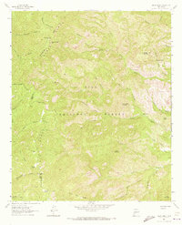
1963 Map of Reeds Peak
USGS Topo · Published 1973About this map
Gila National Forest encompasses this high-altitude landscape in southwestern New Mexico, where the Continental Divide traverses the Black Range. The map documents a rugged network of water sources and seasonal drainages, including the headwaters of the Mimbres River and Diamond Creek. Human presence is marked by isolated landmarks such as Reeds Ranch and Whitmore Cabin, alongside functional infrastructure like the Lookout Tower atop Diamond Peak. The area's topography is defined by significant elevations like Reeds Peak and Cherry Mountain, while a system of labeled routes like the Pack Trail and Jeep Trail suggests the difficult access typical of this wilderness area in the early 1960s. This survey captures a specific moment in land management, showing established points like the Upper Circle Seven Well and Curtis Well which supported livestock or forestry operations in the remote backcountry.
Find a feature on this map
51 named features on this map. Tap any name to fly to it.
Don’t see what you’re looking for? This feature index may not catch every label — zoom into the map to look around manually.
Map Details
Editions of this 1963 Reeds Peak Map
2 editions found
Other maps of this area

1949 · Lookout Mountain
USGS Topo · 1:62,500

1954 · Tularosa
USGS Topo · 1:250,000

1958 · Tularosa
USGS Topo · 1:250,000

1963 · Bonner Canyon
USGS Topo · 1:24,000

1963 · Reeds Peak
USGS Topo · 1:24,000
1963 · Hay Mesa
USGS Topo · 1:24,000

1963 · Sugarloaf Peak
USGS Topo · 1:24,000

1963 · Victoria Park
USGS Topo · 1:24,000

1963 · Apache Peak
USGS Topo · 1:24,000

1965 · Winston
USGS Topo · 1:24,000