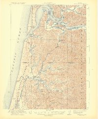
1923 Map of Reedsport
USGS Topo · Published 1923About this map
The Umpqua River and Smith River converge near the established milling and shipping hubs of Gardiner and Reedsport in this 1923 survey. This era of coastal development is defined by a heavy reliance on timber and water-borne commerce, evidenced by the cannery and steamboat labels near Leeds Island. The Southern Pacific RR provides a critical overland link, winding through the valley with stops like Gardiner Sta and School Sta. Further south, the landscape shifts toward the complex freshwater systems of Tenmile Lake and South Tenmile Lake, where small settlements like Lakeside are established. Rural life is anchored by scattered institutions such as Big Creek School and Tenmile School, while the coastline is guarded by the Umpqua LH and a Coast Guard Station at the mouth of the bay.
Find a feature on this map
71 named features on this map. Tap any name to fly to it.
Don’t see what you’re looking for? This feature index may not catch every label — zoom into the map to look around manually.
Map Details
Editions of this 1923 Reedsport Map
4 editions found
Other maps of this area

1896 · Coos Bay
USGS Topo · 1:125,000

1898 · Coos Bay
USGS Topo · 1:125,000

1900 · Coos Bay
USGS Topo · 1:125,000

1919 · Earl
USGS Topo · 1:48,000

1920 · Siltcoos Lake
USGS Topo · 1:62,500

1923 · Reedsport
USGS Topo · 1:62,500

1928 · Sitkum
USGS Topo · 1:125,000

1941 · Siltcoos Lake
USGS Topo · 1:62,500

1942 · Siltcoos Lake
USGS Topo · 1:62,500

1942 · Reedsport
USGS Topo · 1:62,500