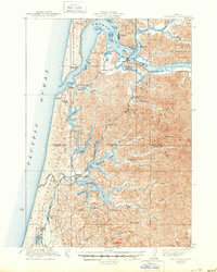
1923 Map of Reedsport
USGS Topo · Published 1950About this map
Gardiner and Reedsport serve as the primary riverfront hubs on this coastal sheet, situated where the Smith River and Scholfield Cr converge into the expansive Umpqua River before meeting the Pacific Ocean. The landscape is a complex network of coastal lakes and tidal inlets, including North Tenmile Lake and Tenmile Lake, which are deeply indented by arms such as Shutter and Devon Arm. The presence of the Umpqua River LH and a Coast Guard Station near Winchester Bay underscores the area's importance for maritime navigation during the early twentieth century.
Find a feature on this map
66 named features on this map. Tap any name to fly to it.
Don’t see what you’re looking for? This feature index may not catch every label — zoom into the map to look around manually.
Map Details
Editions of this 1923 Reedsport Map
4 editions found
Other maps of this area

1896 · Coos Bay
USGS Topo · 1:125,000

1898 · Coos Bay
USGS Topo · 1:125,000

1900 · Coos Bay
USGS Topo · 1:125,000

1919 · Earl
USGS Topo · 1:48,000

1920 · Siltcoos Lake
USGS Topo · 1:62,500

1923 · Reedsport
USGS Topo · 1:62,500

1928 · Sitkum
USGS Topo · 1:125,000

1941 · Siltcoos Lake
USGS Topo · 1:62,500

1942 · Siltcoos Lake
USGS Topo · 1:62,500

1942 · Reedsport
USGS Topo · 1:62,500