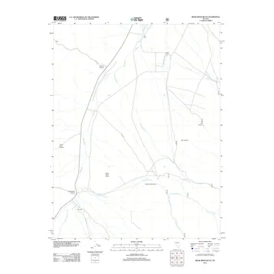
2012 Map of Reese River Butte
USGS Topo · Published 2012About this map
Dyer Ranch and O'Toole Ranch mark the northern reaches of this high desert landscape, where the seasonal course of the Reese River flows through the center of the valley. The terrain is defined by the significant prominence of Reese River Butte and a series of deep drainages cutting into the surrounding uplands, including Elkhorn Canyon and Underdown Canyon. To the south, Heath Ranch sits near the junction of Tierney Creek and the river, illustrating the vital connection between water sources and settlement in this arid environment. The map details a network of primitive routes and trails, such as NFD 087 Trl and Elkhorn Rd, which provide access to remote areas like Devils Gate Canyon and Cottonwood Canyon.
Find a feature on this map
20 named features on this map. Tap any name to fly to it.
Don’t see what you’re looking for? This feature index may not catch every label — zoom into the map to look around manually.
Map Details
Editions of this 2012 Reese River Butte Map
This is the sole edition of this map. No revisions or reprints were ever made.
Other maps of this area

1955 · Millett
USGS Topo · 1:250,000

1956 · North Shoshone Peak
USGS Topo · 1:62,500

1956 · Millett Ranch
USGS Topo · 1:62,500

1956 · Austin
USGS Topo · 1:62,500

1959 · Millett
USGS Topo · 1:250,000

1969 · Dutch Flat
USGS Topo · 1:24,000

1969 · Iron Mountain
USGS Topo · 1:24,000

1985 · Smith Creek Valley
USGS Topo · 1:100,000
1988 · Bunker Hill
USGS Topo · 1:24,000
1988 · Tierney Creek
USGS Topo · 1:24,000