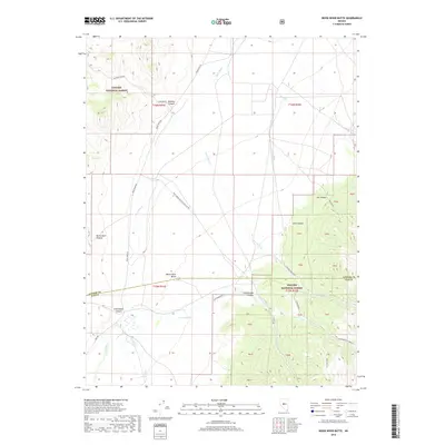
2018 Map of Reese River Butte
USGS Topo · Published 2018About this map
The Reese River defines the central valley of this Nevada landscape, flowing northward between the highlands of the Toiyabe National Forest. This 2018 survey captures a remote section of the Great Basin where the border between Lander Co and Nye Co cuts across the southern reach of the valley. The terrain is marked by significant drainages and landmarks like Reese River Butte, with water sourced from mountain corridors such as Cottonwood Canyon and Elkhorn Canyon.
Find a feature on this map
28 named features on this map. Tap any name to fly to it.
Don’t see what you’re looking for? This feature index may not catch every label — zoom into the map to look around manually.
Map Details
Editions of this 2018 Reese River Butte Map
This is the sole edition of this map. No revisions or reprints were ever made.
Other maps of this area

1955 · Millett
USGS Topo · 1:250,000

1956 · North Shoshone Peak
USGS Topo · 1:62,500

1956 · Millett Ranch
USGS Topo · 1:62,500

1956 · Austin
USGS Topo · 1:62,500

1959 · Millett
USGS Topo · 1:250,000

1969 · Dutch Flat
USGS Topo · 1:24,000

1969 · Iron Mountain
USGS Topo · 1:24,000

1985 · Smith Creek Valley
USGS Topo · 1:100,000
1988 · Bunker Hill
USGS Topo · 1:24,000
1988 · Tierney Creek
USGS Topo · 1:24,000