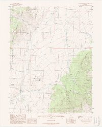
1988 Map of Reese River Butte
USGS Topo · Published 1988About this map
Reese River Valley dominates the central corridor of this Nevada landscape, where the seasonal flows of the Reese River are supplemented by a network of human intervention, including a Well, a Ditch, and an Aqueduct. The high country of the Toiyabe National Forest brackets the valley on both sides, with the terrain carved by numerous canyons such as Devils Gate Canyon and Underdown Canyon. Localized industry and land use are evident through features like the Millett Ranch and various extraction sites, including a Gravel Pit, a Mine Shaft, and several Prospect marks. The survey captures the transition between the valley floor and the steep peaks of the Toiyabe Range, notably marked by the prominent Reese River Butte and the boundary line where Lander County meets Nye County.
Find a feature on this map
26 named features on this map. Tap any name to fly to it.
Don’t see what you’re looking for? This feature index may not catch every label — zoom into the map to look around manually.
Map Details
Editions of this 1988 Reese River Butte Map
This is the sole edition of this map. No revisions or reprints were ever made.
Other maps of this area

1955 · Millett
USGS Topo · 1:250,000

1956 · North Shoshone Peak
USGS Topo · 1:62,500

1956 · Millett Ranch
USGS Topo · 1:62,500

1956 · Austin
USGS Topo · 1:62,500

1959 · Millett
USGS Topo · 1:250,000

1969 · Dutch Flat
USGS Topo · 1:24,000

1969 · Iron Mountain
USGS Topo · 1:24,000

1985 · Smith Creek Valley
USGS Topo · 1:100,000
1988 · Bunker Hill
USGS Topo · 1:24,000
1988 · Tierney Creek
USGS Topo · 1:24,000