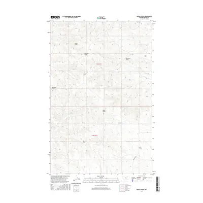
2017 Map of Regal Coulee
USGS Topo · Published 2017About this map
Regal Coulee and the surrounding drainage network of Phillips County define this high plains landscape. The terrain is deeply incised by numerous named coulees, including Thomas Coulee, Gilbertson Coulee, and the grimly named Dead Horse Coulee. These geographical features reveal how water moves across this semi-arid environment, feeding into ephemeral streams like Third Cr and Fourth Cr.
Find a feature on this map
16 named features on this map. Tap any name to fly to it.
Don’t see what you’re looking for? This feature index may not catch every label — zoom into the map to look around manually.
Map Details
Editions of this 2017 Regal Coulee Map
This is the sole edition of this map. No revisions or reprints were ever made.
Other maps of this area

1905 · Bowdoin
USGS Topo · 1:62,500

1905 · Saco Special
USGS Topo · 1:62,500

1954 · Glasgow
USGS Topo · 1:250,000

1957 · Glasgow
USGS Topo · 1:250,000

1958 · Glasgow
USGS Topo · 1:250,000

1984 · Pinks
USGS Topo · 1:24,000
1984 · Robinson Ranch
USGS Topo · 1:24,000

1984 · Harb
USGS Topo · 1:24,000
1984 · Bowdoin
USGS Topo · 1:24,000
1984 · Saco
USGS Topo · 1:24,000