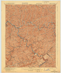
1917 Map of Regina
USGS Topo · Published 1932About this map
Pine Mountain anchors the southern boundary of this Appalachian landscape, where the jagged topography of eastern Kentucky meets Virginia. The region is defined by the winding course of the Levisa Fork and Russell Fork rivers, which carved deep valleys that became the primary corridors for settlement and industry. Several communities here are identified by dual names reflecting the vital role of early postal operations, such as Elkhorn City Praise PO and Marrowbone Regina PO.
Find a feature on this map
72 named features on this map. Tap any name to fly to it.
Don’t see what you’re looking for? This feature index may not catch every label — zoom into the map to look around manually.
Map Details
Editions of this 1917 Regina Map
3 editions found
Other maps of this area

1886 · Prestonsburg
USGS Topo · 1:125,000

1886 · Grundy
USGS Topo · 1:125,000

1887 · Warfield
USGS Topo · 1:125,000

1890 · Whitesburg
USGS Topo · 1:125,000

1890 · Grundy
USGS Topo · 1:125,000

1891 · Warfield
USGS Topo · 1:125,000

1892 · Grundy
USGS Topo · 1:125,000

1892 · Whitesburg
USGS Topo · 1:125,000

1892 · Prestonsburg
USGS Topo · 1:125,000

1909 · Matewan
USGS Topo · 1:48,000