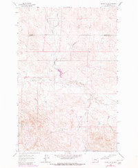
1963 Map of Regnal Coulee
USGS Topo · Published 1980About this map
The high plains of eastern Montana are defined by the intricate drainage systems of Big Breed Creek and Beaverhalt Creek as they weave through the landscape of the early 1960s. This USGS survey highlights the complex topography of the region, where the boundary between Garfield Co and Rosebud Co cuts across a network of coulees and breaks. The 1980 revision of this map introduces updates from 1978 aerial photography, showing the evolution of the land use in this ranching country. Landform features like Regnal Coulee, Diego Coulee, and the curiously named Studhorse Coulee demonstrate the erosional patterns of the local watershed. While the area is largely undeveloped, the presence of isolated infrastructure such as a Well and Drill Hole points to the subsurface exploration and water management critical to this arid environment.
Find a feature on this map
8 named features on this map. Tap any name to fly to it.
Don’t see what you’re looking for? This feature index may not catch every label — zoom into the map to look around manually.
Map Details
Editions of this 1963 Regnal Coulee Map
2 editions found
Other maps of this area

1954 · Forsyth
USGS Topo · 1:250,000

1957 · Forsyth
USGS Topo · 1:250,000

1958 · Forsyth
USGS Topo · 1:250,000

1960 · Yablonski Ranch
USGS Topo · 1:24,000

1962 · Kincheloe Ranch
USGS Topo · 1:24,000

1962 · Grebe Ranch
USGS Topo · 1:24,000

1963 · Mc Williams Springs
USGS Topo · 1:24,000

1963 · Hecker Ranch
USGS Topo · 1:24,000
1963 · Dutton Ranch
USGS Topo · 1:24,000

1963 · Regnal Coulee
USGS Topo · 1:24,000