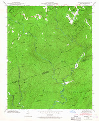
1946 Map of Reid
USGS Topo · Published 1967About this map
Toxaway Ch and the Oakland Cem stand near the northern edge of this terrain where the Tenn Valley Divide snakes through the high country. Surveyed shortly after the war, this landscape is defined by the dramatic descent of the Toxaway River, Thompson River, and Whitewater River as they flow south across the state line. Significant landmarks like Toxaway Falls and Rainbow Falls mark the steep elevation changes of the Blue Ridge escarpment. Local travel in the 1940s relied on routes such as Bohaynee Road and Bearwallow Road, connecting small settlements like Oakland and Reid before the wilderness of the Nantahala National Forest and Sumter National Forest takes over. The map preserves the location of isolated mountain homes and the complex network of ridges, including Hogback Ridge and Narrow Rock Ridge.
Find a feature on this map
64 named features on this map. Tap any name to fly to it.
Don’t see what you’re looking for? This feature index may not catch every label — zoom into the map to look around manually.
Map Details
Editions of this 1946 Reid Map
4 editions found
Other maps of this area

1886 · Walhalla
USGS Topo · 1:125,000

1888 · Pickens
USGS Topo · 1:125,000

1891 · Cowee
USGS Topo · 1:125,000

1892 · Walhalla
USGS Topo · 1:125,000

1894 · Pickens
USGS Topo · 1:125,000

1896 · Walhalla
USGS Topo · 1:125,000

1897 · Cowee
USGS Topo · 1:125,000

1905 · Pisgah
USGS Topo · 1:125,000

1906 · Pisgah
USGS Topo · 1:125,000

1907 · Cowee
USGS Topo · 1:125,000