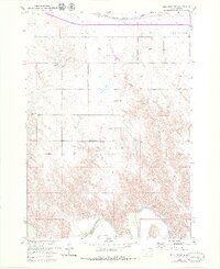
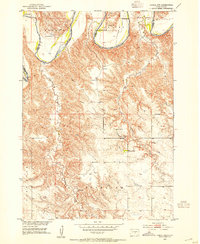
1952 Map of Reliance SW
USGS Topo · Published 1979About this map
The White River forms a wide, meandering boundary between Lyman and Tripp Counties, carving through the plains south of the Red Butte upland. This mid-century landscape reflects a rural infrastructure built around localized community centers, where landmarks like Roosevelt Sch and Hieb Sch served the surrounding ranching families. The presence of a Flowing Well near Bud Creek underscores the critical importance of water management in this semi-arid environment, supporting operations like the Nelson Ranch. Near the northern edge, the Chicago Milwaukee St Paul and Pacific railroad corridor cuts across the townships of Reliance and Bailey, while local history is preserved at the Trinity Cem and Reformed Ch Cem.
Find a feature on this map
17 named features on this map. Tap any name to fly to it.
Don’t see what you’re looking for? This feature index may not catch every label — zoom into the map to look around manually.
Map Details
Editions of this 1952 Reliance SW Map
3 editions found
Other maps of this area
1951 · Ideal NE
USGS Topo · 1:24,000
1952 · Reliance SW
USGS Topo · 1:24,000

1952 · Reliance SE
USGS Topo · 1:24,000
1952 · Hamill NW
USGS Topo · 1:24,000

1952 · Hamill NE
USGS Topo · 1:24,000

1955 · Mitchell
USGS Topo · 1:250,000

1959 · Mitchell
USGS Topo · 1:250,000
1978 · Lyman
USGS Topo · 1:24,000
1978 · Kennebec SE
USGS Topo · 1:24,000
1978 · Reliance
USGS Topo · 1:24,000