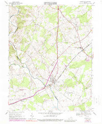
1966 Map of Remington
USGS Topo · Published 1988About this map
The Rappahannock River and Hazel River converge in the southern portion of this landscape, marking the natural boundary between Culpeper and Fauquier Counties. The town of Remington serves as a central hub, situated where the Southern railroad line crosses the river. This rail corridor facilitates a string of rural settlements, including Bealeton and Elkwood, reflecting a mid-century period of regional transit and commerce. Significant land use is noted by the U S Military Res Warrenton Training Center and the Culpeper Municipal Airport T I Martin Field.
Find a feature on this map
39 named features on this map. Tap any name to fly to it.
Don’t see what you’re looking for? This feature index may not catch every label — zoom into the map to look around manually.
Map Details
Editions of this 1966 Remington Map
4 editions found
Other maps of this area

1887 · Spottsylvania
USGS Topo · 1:125,000

1892 · Spottsylvania
USGS Topo · 1:125,000

1894 · Warrenton
USGS Topo · 1:125,000

1894 · Warrenton
USGS Topo · 1:62,500

1927 · Remington
USGS Topo · 1:48,000

1930 · Warrenton
USGS Topo · 1:62,500

1943 · Catlett
USGS Topo · 1:62,500

1943 · Germanna Bridge
USGS Topo · 1:24,000

1943 · Culpeper
USGS Topo · 1:24,000

1943 · Midland
USGS Topo · 1:24,000