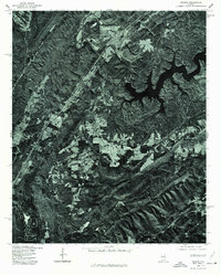
1975 Map of Remlap
USGS Topo · Published 1977About this map
Blackburn Fork Little Warrior River snakes through this Blount County landscape, illustrating the intricate topography of north-central Alabama in the mid-1970s. The aerial photoimagery captures a distinct contrast between the deeply forested ridges and the irregular patches of cleared agricultural land that follow the valley floors. In the eastern portion of the quadrangle, the sprawling fingers of Inland Lake dominate the terrain, created by the damming of the river to provide a steady industrial water supply. The settlement of Remlap sits along the primary transit corridor in the west, serving as a focal point for a rural community defined by its proximity to both the winding river and the expansive reservoir. This orthophoto provides a precise visual record of land use and timber patterns before further modern development altered these traditional woodland and farming boundaries.
Find a feature on this map
3 named features on this map. Tap any name to fly to it.
Don’t see what you’re looking for? This feature index may not catch every label — zoom into the map to look around manually.
Map Details
Editions of this 1975 Remlap Map
This is the sole edition of this map. No revisions or reprints were ever made.
Other maps of this area

1889 · Springville
USGS Topo · 1:125,000

1889 · Birmingham
USGS Topo · 1:125,000

1892 · Birmingham
USGS Topo · 1:125,000

1892 · Springville
USGS Topo · 1:125,000

1895 · Birmingham
USGS Topo · 1:125,000

1905 · Leeds
USGS Topo · 1:62,500

1907 · Birmingham
USGS Topo · 1:125,000

1907 · Leeds
USGS Topo · 1:62,500

1953 · Birmingham
USGS Topo · 1:250,000

1956 · Birmingham
USGS Topo · 1:250,000