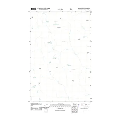
2011 Map of Remmel Mountain
USGS Topo · Published 2011About this map
Remmel Mountain and the high ridges along the international border define this high-altitude landscape in the Pasayten Wilderness area. In 2011, this survey recorded a terrain of peaks and passes where names like Wolframite Mountain and Tungsten Creek suggest a history of prospecting for heavy metals in the northern Cascades. The map details a complex drainage system where the Chewuch River and Andrews Creek originate from alpine waters such as Lower Cathedral Lake and Upper Cathedral Lake. High-elevation crossings including Apex Pass, Cathedral Pass, and Andrew Pass connect these drainages, illustrating the routes used by early travelers and surveyors to navigate the divide. These natural features, alongside prominent landmarks like Cathedral Peak and Amphitheater Mountain, provide a look at the geography before the widespread use of digital navigation tools, capturing the remote character of the Washington-British Columbia borderlands.
Find a feature on this map
42 named features on this map. Tap any name to fly to it.
Don’t see what you’re looking for? This feature index may not catch every label — zoom into the map to look around manually.
Map Details
Editions of this 2011 Remmel Mountain Map
This is the sole edition of this map. No revisions or reprints were ever made.
Other maps of this area

1955 · Concrete
USGS Topo · 1:250,000

1958 · Concrete
USGS Topo · 1:250,000

1962 · Concrete
USGS Topo · 1:250,000

1969 · Mt. Barney
USGS Topo · 1:24,000

1969 · Remmel Mtn.
USGS Topo · 1:24,000

1969 · Billy Goat Mtn
USGS Topo · 1:24,000

1969 · Ashnola Pass
USGS Topo · 1:24,000
1969 · Coleman Peak
USGS Topo · 1:24,000
1969 · Bauerman Ridge
USGS Topo · 1:24,000
2001 · Coleman Peak
USGS Topo · 1:24,000