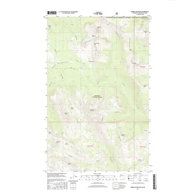
2017 Map of Remmel Mountain
USGS Topo · Published 2017About this map
Okanogan National Forest defines this high-elevation landscape along the international border, where the Pacific NW National Scenic Trail traverses a series of prominent peaks and alpine passes. The terrain is centered on Remmel Mountain and the high ridges that separate the Chewuch River from its numerous tributaries, including Andrews Creek and Spanish Creek. This 2017 survey details a network of backcountry routes such as the Remmel-Cutoff and Peepsight trail, which connect remote water bodies like Peepsight Lake and Four Point Lake. The prominence of Cathedral Peak and Wolframite Mtn near the Canadian border illustrates the geological continuity of the North Cascades, while features like Crazy Man Pass and Cathedral Pass highlight the historical routes used to navigate these formidable summits.
Find a feature on this map
54 named features on this map. Tap any name to fly to it.
Don’t see what you’re looking for? This feature index may not catch every label — zoom into the map to look around manually.
Map Details
Editions of this 2017 Remmel Mountain Map
This is the sole edition of this map. No revisions or reprints were ever made.
Other maps of this area

1955 · Concrete
USGS Topo · 1:250,000

1958 · Concrete
USGS Topo · 1:250,000

1962 · Concrete
USGS Topo · 1:250,000

1969 · Mt. Barney
USGS Topo · 1:24,000

1969 · Remmel Mtn.
USGS Topo · 1:24,000

1969 · Billy Goat Mtn
USGS Topo · 1:24,000

1969 · Ashnola Pass
USGS Topo · 1:24,000
1969 · Coleman Peak
USGS Topo · 1:24,000
1969 · Bauerman Ridge
USGS Topo · 1:24,000
2001 · Coleman Peak
USGS Topo · 1:24,000