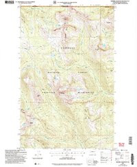
2002 Map of Remmel Mountain
USGS Topo · Published 2006About this map
Okanogan National Forest dominates this high-altitude landscape along the international boundary between British Columbia and Washington. This 2002 revision shows the protected geography of the Pasayten Wilderness, a region defined by dramatic peaks and alpine basins. A notable industrial feature is the Tungsten Mine near Apex Pass, providing a window into the mineral extraction history of the Tungsten Creek drainage. The terrain is marked by prominent summits such as Remmel Mountain and Amphitheater Mountain, while numerous high-elevation water bodies like Upper Cathedral Lake and Cornwell Lake cluster in the glacial cirques. The Tungsten Trail and other primitive routes offer the only access through this roadless area, connecting passes like Andrew Pass and Cathedral Pass.
Find a feature on this map
54 named features on this map. Tap any name to fly to it.
Don’t see what you’re looking for? This feature index may not catch every label — zoom into the map to look around manually.
Map Details
Editions of this 2002 Remmel Mountain Map
This is the sole edition of this map. No revisions or reprints were ever made.
Other maps of this area

1955 · Concrete
USGS Topo · 1:250,000

1958 · Concrete
USGS Topo · 1:250,000

1962 · Concrete
USGS Topo · 1:250,000

1969 · Mt. Barney
USGS Topo · 1:24,000

1969 · Remmel Mtn.
USGS Topo · 1:24,000

1969 · Billy Goat Mtn
USGS Topo · 1:24,000

1969 · Ashnola Pass
USGS Topo · 1:24,000
1969 · Coleman Peak
USGS Topo · 1:24,000
1969 · Bauerman Ridge
USGS Topo · 1:24,000
2001 · Coleman Peak
USGS Topo · 1:24,000