
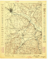
1946 Map of Remsen
USGS Topo · Published 1946About this map
Cincinnati Creek and the New York Central railroad corridor define the central valley of this Oneida County landscape just after the second World War. The region is marked by a deep Welsh cultural heritage, evidenced by several distinct chapels such as Penn-Y-Grig Ch, Capel Ucha Ch, and Enlli Ch. Near Sixty Corners, the Baron Von Steuben Monument honors the Revolutionary War figure on the hills overlooking Steuben Cr. The eastern edge of the survey follows the dramatic course of West Canada Creek, where the Hydroelectric Plant and a complex Feeder Canal system near Trenton Falls highlight the era's industrial utility of the waterways. To the south, the village of Trenton Barneveld P O serves as a local hub alongside Barneveld Sta, while smaller settlements like Mapledale and Prospect remain connected by the winding rural road network.
Find a feature on this map
48 named features on this map. Tap any name to fly to it.
Don’t see what you’re looking for? This feature index may not catch every label — zoom into the map to look around manually.
Map Details
Editions of this 1946 Remsen Map
This is the sole edition of this map. No revisions or reprints were ever made.
Other maps of this area

1895 · Oriskany
USGS Topo · 1:62,500

1897 · Remsen
USGS Topo · 1:62,500

1898 · Utica
USGS Topo · 1:62,500
1898 · Oriskany
USGS Topo · 1:62,500

1900 · Utica
USGS Topo · 1:62,500

1900 · Remsen
USGS Topo · 1:62,500

1904 · Boonville
USGS Topo · 1:62,500
1943 · Newport
USGS Topo · 1:24,000

1945 · South Trenton
USGS Topo · 1:31,680

1945 · Newport
USGS Topo · 1:31,680